Features
| mpn | 926806-30-3 |
|---|---|
| Brand | Backroad Map |
| DropShip | No |
| Oversized | No |
| Qty/Pack | 1 |
| ShipsAlone | No |
Details
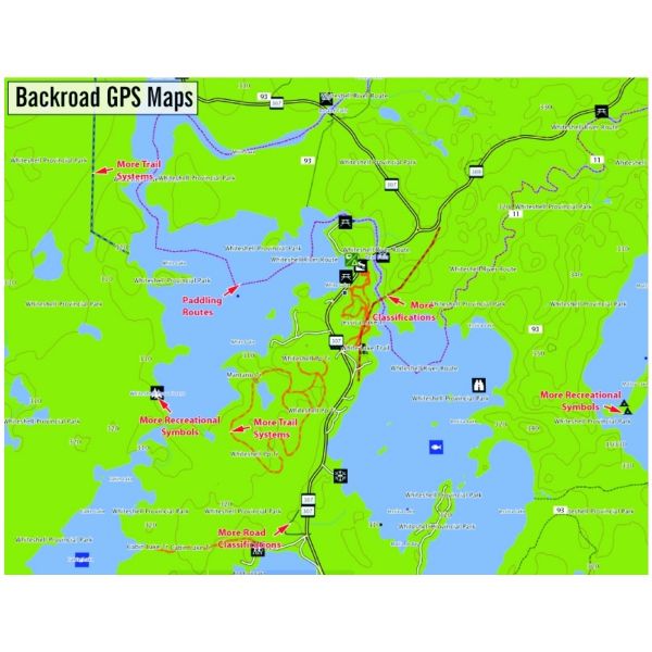
Backroad Map books are proud to release their new Garmin GPS compatible line of topographic maps for Manitoba. Now users can have access to our industry leading road and recreation maps in the palm of their hands. No other source offers as up-to-date backroad, trail and recreation data for all of Manitoba like we do. The Backroad Manitoba GPS Maps also have the added value of detailed city and highway information to provide a safe and reliable product that will truly get you from your home to the Great Outdoors. In addition to easy access to the patented Backroad Map book Points of Interest and recreation descriptions, you can even use the Manitoba GPS Maps in Garmin's MapSource®, Basecamp™ and RoadTrip™.
Listed below are some of features that make our Manitoba Backroad GPS Maps unique and ideal for the outdoor enthusiast.
Manitoba GPS Map Specific Features:• Garmin GPS, Basecamp™, MapSource® and RoadTrip™ compatible
• 20,000 & 50,000 scale TOPO maps (50,000 north of 53')
• The most complete Resource, Industry and Bush road coverage available for Manitoba
• Routable City, Resource and Industry Roads
• Tens of thousands of kilometers of trail systems, including defined ATV, Paddling, Snowmobile & multi-use trails
• Smart background & Searchable Wildlife Management Areas (GHA)
• Parks & Campsites
• Lake & Stream Fishing information with boat launches
• Hundreds of Outdoor Recreation symbols and Points of Interest
• Searchable Backroad recreation information for fishing, paddling, parks, trails and more
• Boat launches, campsites, paddling access points, ski areas and more
• Tens of thousands of Searchable cities, Geographic Land and Water features and much more!
Note that all the standard Garmin GPS map features like seamless topographic maps, the find tool to locate nearby city, water or recreation features, 20,000-50,000 scale geographic points and city navigation are all part of the Backroad BC GPS Maps package.
Unique to the Backroad GPS Maps are our Custom or Backroad POI sets. Within each province we have close to 100,000 searchable points. You can use these to help navigate by selecting the Whereto and then Go! option or read what each site offers through the More option. This added feature to our GPS Maps gives you the descriptions or write-ups of most recreation sites that have been geo-referenced from the popular Backroad Map book guidebook series.
Manitoba Custom POI Highlights:
• Fishing Lakes with 530 locations• Trails with over 180 trailheads
• ATV Trails with over 15 trailheads
• Snowmobile Trails with over 25 trailheads
• Regional Parks with over 330 locations
• National and Provincial Parks with over 120 Parks
• Winter Recreation Sites including over 65 Cross-country ski trail locations and most downhill ski areas
• Over 70 Manitoba Boat Launch locations
• Over 170 Paddling Access Points and Paddling Route descriptions
• Over 150 Private Campsites and Back country Resorts
• Over 160 Back country Campsites
• Over 1,400 Communities
• Over 11,000 searchable Geographic Features
• Over 70 Wildlife Management Areas
Backroad Extras
Backroad Extras are where you find all the POI information specific to our Backroad GPS Maps.Manitoba's Extra Categories:
• Attractions• ATV
• Back country Camps
• Boat Launches
• Campsites
• Cities
• Fishing
• Golf
• GHA - Hunting Areas
• Lakes
• Land Features
• Marina
• Misc Water Feature
• Paddling - Routes
• Parks - National
• Parks - Provincial
• Parks - Urban
• Picnic
• Public Services
• Resorts
• Restaurants
• Rivers and Creeks
• Snowmobile Routes
• Trails
• Transportation
• Wildlife Viewing
• Winter Recreation
• WMA - Wildlife Management Areas
Order Chart
| Product | mpn | Oversized | Qty/Pack | Price | Add to cart |
|---|---|---|---|---|---|
 | mpn 926806-30-3 | Oversized No | Qty/Pack 1 | Price $99.95 | Out of stock |